StandardAtmospheres
•Functions and parameters contained in
this package:
In[1]:=
![RadarPackageFunctions[StandardAtmospheres, 2]](HTMLFiles/index_1.gif)
Out[1]//DisplayForm=
![[Graphics:HTMLFiles/index_2.gif]](HTMLFiles/index_2.gif)
•Package functions and their basic documentation
along with simple examples
•FindStationReport
![[Graphics:HTMLFiles/index_3.gif]](HTMLFiles/index_3.gif)
In[2]:=
![FindStationReport["len"]](HTMLFiles/index_4.gif)
![[Graphics:HTMLFiles/index_5.gif]](HTMLFiles/index_5.gif)
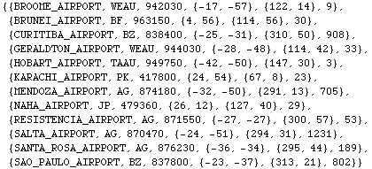
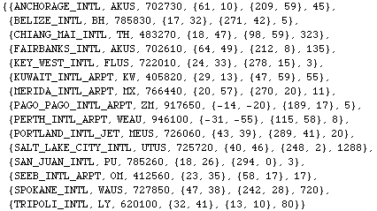
In[3]:=
![FindStationReport[{40, 42}, {-74, 0}, 400]](HTMLFiles/index_6.gif)
![[Graphics:HTMLFiles/index_7.gif]](HTMLFiles/index_7.gif)
•FindStation
![[Graphics:HTMLFiles/index_8.gif]](HTMLFiles/index_8.gif)
In[4]:=
![FindStation["airport"]](HTMLFiles/index_9.gif)
Out[4]=
In[5]:=
![FindStation["intl"]](HTMLFiles/index_11.gif)
Out[5]=
•FindStationFull
![[Graphics:HTMLFiles/index_13.gif]](HTMLFiles/index_13.gif)
Usage message for FindStationFull
•FindStationFullReport
![[Graphics:HTMLFiles/index_14.gif]](HTMLFiles/index_14.gif)
Usage message for FindStationFullReport
•GeometricalHeight
![[Graphics:HTMLFiles/index_15.gif]](HTMLFiles/index_15.gif)
In[6]:=
![GeometricalHeight[h]](HTMLFiles/index_16.gif)
Out[6]=
•GeopotentialHeight
![[Graphics:HTMLFiles/index_18.gif]](HTMLFiles/index_18.gif)
In[7]:=
![GeopotentialHeight[h]](HTMLFiles/index_19.gif)
Out[7]=
•HeightTopographic
![[Graphics:HTMLFiles/index_21.gif]](HTMLFiles/index_21.gif)
To find the location of Denver Co, first load the
Mathematica standate add-on package Miscellaneous`CityData`
In[8]:=
![Needs["Miscellaneous`CityData`"] ;](HTMLFiles/index_22.gif)
In[9]:=
![denverLocation = CityData["Denver", CityPosition]](HTMLFiles/index_23.gif)
Out[9]=

Denver is known as the "Mile High City". This
appears to be roughly accurate:
In[10]:=
![HeightTopographic[Sequence @@ denverLocation] MetersToMiles](HTMLFiles/index_25.gif)
Out[10]=

Here is an uncalibrated color rendition of the data:
In[11]:=
![DensityPlot[HeightTopographic[lat, long], {long, -180, 180}, {lat, -90, 90}, ColorFunction -> Hue, PlotPoints -> 200, Mesh -> False, AspectRatio -> Automatic] ;](HTMLFiles/index_27.gif)
![[Graphics:HTMLFiles/index_28.gif]](HTMLFiles/index_28.gif)
•MeanTemperature
![[Graphics:HTMLFiles/index_29.gif]](HTMLFiles/index_29.gif)
In[12]:=
![FindStationReport["mx"]](HTMLFiles/index_30.gif)
![[Graphics:HTMLFiles/index_31.gif]](HTMLFiles/index_31.gif)
It is cooler in the mean at a high elevation in Mexico...
In[13]:=
![KelvinToFarenheit[MeanTemperature[{28, 42}, {253, 56}]]](HTMLFiles/index_32.gif)
Out[13]=

...than at a costal location:
In[14]:=
![KelvinToFarenheit[MeanTemperature[{23, 12}, {253, 35}]]](HTMLFiles/index_34.gif)
Out[14]=

Here is an uncalibrated color rendition of the data:
In[15]:=
![DensityPlot[MeanTemperature[lat, long], {long, -180, 180}, {lat, -90, 90}, ColorFunction -> Hue, PlotPoints -> 150, Mesh -> False, AspectRatio -> Automatic] ;](HTMLFiles/index_36.gif)
![[Graphics:HTMLFiles/index_37.gif]](HTMLFiles/index_37.gif)
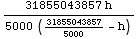
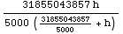
•Pressure1976
![[Graphics:HTMLFiles/index_38.gif]](HTMLFiles/index_38.gif)
In[16]:=
![pressurePlot1976 = Plot[Pressure1976[h KilometersToMeters], {h, 0, 50}, Frame -> True, Exch ... abel -> {"Pressure", "Height (km)"}, PlotStyle -> {RGBColor[1, 0, 0]}] ;](HTMLFiles/index_39.gif)
![[Graphics:HTMLFiles/index_40.gif]](HTMLFiles/index_40.gif)
•PressureCOSPAR
![[Graphics:HTMLFiles/index_41.gif]](HTMLFiles/index_41.gif)
In[17]:=
![pressurePlotCOSPAR = Plot[PressureCOSPAR[h KilometersToMeters], {h, 0, 50}, Frame -> True, ... abel -> {"Pressure", "Height (km)"}, PlotStyle -> {RGBColor[0, 1, 0]}] ;](HTMLFiles/index_42.gif)
![[Graphics:HTMLFiles/index_43.gif]](HTMLFiles/index_43.gif)
In[18]:=
![Show[pressurePlot1976, pressurePlotCOSPAR, ImageSize -> 400] ;](HTMLFiles/index_44.gif)
![[Graphics:HTMLFiles/index_45.gif]](HTMLFiles/index_45.gif)
•PressureITU
![[Graphics:HTMLFiles/index_46.gif]](HTMLFiles/index_46.gif)
•PressureLowLatitude
![[Graphics:HTMLFiles/index_47.gif]](HTMLFiles/index_47.gif)
Usage message for PressureLowLatitude
In[19]:=
![Plot[PressureLowLatitude[h KilometersToMeters], {h, 0, 50}, Frame -> True, Axes -> False ... abel -> {"Pressure", "Height (km)"}, PlotStyle -> {RGBColor[0, 1, 0]}] ;](HTMLFiles/index_48.gif)
![[Graphics:HTMLFiles/index_49.gif]](HTMLFiles/index_49.gif)
•PressureSummerHighLatitude
![[Graphics:HTMLFiles/index_50.gif]](HTMLFiles/index_50.gif)
In[20]:=
![Plot[PressureSummerHighLatitude[h KilometersToMeters], {h, 0, 50}, Frame -> True, Axes -> ... abel -> {"Pressure", "Height (km)"}, PlotStyle -> {RGBColor[0, 1, 0]}] ;](HTMLFiles/index_51.gif)
![[Graphics:HTMLFiles/index_52.gif]](HTMLFiles/index_52.gif)
•PressureSummerMidLatitude
![[Graphics:HTMLFiles/index_53.gif]](HTMLFiles/index_53.gif)
In[21]:=
![Plot[PressureSummerMidLatitude[h KilometersToMeters], {h, 0, 50}, Frame -> True, Axes -> ... abel -> {"Pressure", "Height (km)"}, PlotStyle -> {RGBColor[0, 1, 0]}] ;](HTMLFiles/index_54.gif)
![[Graphics:HTMLFiles/index_55.gif]](HTMLFiles/index_55.gif)
•PressureWinterHighLatitude
![[Graphics:HTMLFiles/index_56.gif]](HTMLFiles/index_56.gif)
In[22]:=
![Plot[PressureWinterHighLatitude[h KilometersToMeters], {h, 0, 50}, Frame -> True, Axes -> ... abel -> {"Pressure", "Height (km)"}, PlotStyle -> {RGBColor[0, 1, 0]}] ;](HTMLFiles/index_57.gif)
![[Graphics:HTMLFiles/index_58.gif]](HTMLFiles/index_58.gif)
•PressureWinterMidLatitude
![[Graphics:HTMLFiles/index_59.gif]](HTMLFiles/index_59.gif)
In[23]:=
![Plot[PressureWinterMidLatitude[h KilometersToMeters], {h, 0, 50}, Frame -> True, Axes -> ... abel -> {"Pressure", "Height (km)"}, PlotStyle -> {RGBColor[0, 1, 0]}] ;](HTMLFiles/index_60.gif)
![[Graphics:HTMLFiles/index_61.gif]](HTMLFiles/index_61.gif)
•RelativeHumidity
![[Graphics:HTMLFiles/index_62.gif]](HTMLFiles/index_62.gif)
In[24]:=
![RelativeHumidity[WaterVaporDensityLowLatitude[0], SaturatedVaporDensity[TemperatureLowLatitude[0]]]](HTMLFiles/index_63.gif)
Out[24]=

•SaturatedVaporDensity
![[Graphics:HTMLFiles/index_65.gif]](HTMLFiles/index_65.gif)
In[25]:=
![SaturatedVaporDensity[TemperatureLowLatitude[0]]](HTMLFiles/index_66.gif)
Out[25]=

In[26]:=
![WaterVaporDensityLowLatitude[0]](HTMLFiles/index_68.gif)
Out[26]=

•StandardAtmospheres
![[Graphics:HTMLFiles/index_70.gif]](HTMLFiles/index_70.gif)
•Temperature1976
![[Graphics:HTMLFiles/index_71.gif]](HTMLFiles/index_71.gif)
In[27]:=
![temperature1976 = Plot[Temperature1976[h KilometersToMeters], {h, 0, 200}, Frame -> True, Exchanged -> True, FrameLabel -> {"Temperature", "Height (km)"}] ;](HTMLFiles/index_72.gif)
![[Graphics:HTMLFiles/index_73.gif]](HTMLFiles/index_73.gif)
•TemperatureCOSPAR
![[Graphics:HTMLFiles/index_74.gif]](HTMLFiles/index_74.gif)
In[28]:=
![temperatureCOSPARFebruary45 = Plot[TemperatureCOSPAR[February, h KilometersToMeters, 45], {h, ... -> {"Temperature", "Height (km)"}, PlotStyle -> {RGBColor[1, .2, .2]}] ;](HTMLFiles/index_75.gif)
![[Graphics:HTMLFiles/index_76.gif]](HTMLFiles/index_76.gif)
In[29]:=
![temperatureCOSPARJuly45 = Plot[TemperatureCOSPAR[July, h KilometersToMeters, 45], {h, 0, 100}, ... -> {"Temperature", "Height (km)"}, PlotStyle -> {RGBColor[.2, 1, .2]}] ;](HTMLFiles/index_77.gif)
![[Graphics:HTMLFiles/index_78.gif]](HTMLFiles/index_78.gif)
In[30]:=
![Show[temperature1976, temperatureCOSPARFebruary45, temperatureCOSPARJuly45, Axes -> False] ;](HTMLFiles/index_79.gif)
![[Graphics:HTMLFiles/index_80.gif]](HTMLFiles/index_80.gif)
•TemperatureITU
![[Graphics:HTMLFiles/index_81.gif]](HTMLFiles/index_81.gif)
•TemperatureLowLatitude
![[Graphics:HTMLFiles/index_82.gif]](HTMLFiles/index_82.gif)
In[31]:=
![Plot[TemperatureLowLatitude[h KilometersToMeters], {h, 0, 100}, Frame -> True, Exchanged -& ... -> {"Temperature", "Height (km)"}, PlotStyle -> {RGBColor[.2, 1, .2]}] ;](HTMLFiles/index_83.gif)
![[Graphics:HTMLFiles/index_84.gif]](HTMLFiles/index_84.gif)
•TemperatureSummerHighLatitude
![[Graphics:HTMLFiles/index_85.gif]](HTMLFiles/index_85.gif)
In[32]:=
![Plot[TemperatureSummerHighLatitude[h KilometersToMeters], {h, 0, 100}, Frame -> True, Excha ... -> {"Temperature", "Height (km)"}, PlotStyle -> {RGBColor[.2, 1, .2]}] ;](HTMLFiles/index_86.gif)
![[Graphics:HTMLFiles/index_87.gif]](HTMLFiles/index_87.gif)
•TemperatureSummerMidLatitude
![[Graphics:HTMLFiles/index_88.gif]](HTMLFiles/index_88.gif)
In[33]:=
![Plot[TemperatureSummerMidLatitude[h KilometersToMeters], {h, 0, 100}, Frame -> True, Exchan ... -> {"Temperature", "Height (km)"}, PlotStyle -> {RGBColor[.2, 1, .2]}] ;](HTMLFiles/index_89.gif)
![[Graphics:HTMLFiles/index_90.gif]](HTMLFiles/index_90.gif)
•TemperatureWinterHighLatitude
![[Graphics:HTMLFiles/index_91.gif]](HTMLFiles/index_91.gif)
In[34]:=
![Plot[TemperatureWinterHighLatitude[h KilometersToMeters], {h, 0, 100}, Frame -> True, Excha ... -> {"Temperature", "Height (km)"}, PlotStyle -> {RGBColor[.2, 1, .2]}] ;](HTMLFiles/index_92.gif)
![[Graphics:HTMLFiles/index_93.gif]](HTMLFiles/index_93.gif)
•TemperatureWinterMidLatitude
![[Graphics:HTMLFiles/index_94.gif]](HTMLFiles/index_94.gif)
In[35]:=
![temperatureWinterMidLatitude = Plot[TemperatureWinterMidLatitude[h KilometersToMeters], {h, 0, ... -> {"Temperature", "Height (km)"}, PlotStyle -> {RGBColor[.2, 1, .2]}] ;](HTMLFiles/index_95.gif)
![[Graphics:HTMLFiles/index_96.gif]](HTMLFiles/index_96.gif)
In[36]:=
![Show[temperatureCOSPARFebruary45, temperatureWinterMidLatitude, Axes -> False] ;](HTMLFiles/index_97.gif)
![[Graphics:HTMLFiles/index_98.gif]](HTMLFiles/index_98.gif)
•VaporDensity
![[Graphics:HTMLFiles/index_99.gif]](HTMLFiles/index_99.gif)
•WaterVaporDensityITU
![[Graphics:HTMLFiles/index_100.gif]](HTMLFiles/index_100.gif)
•WaterVaporDensityLowLatitude
![[Graphics:HTMLFiles/index_101.gif]](HTMLFiles/index_101.gif)
•WaterVaporDensityMidLatitudeMean
![[Graphics:HTMLFiles/index_102.gif]](HTMLFiles/index_102.gif)
In[37]:=
![Plot[WaterVaporDensityMidLatitudeMean[h KilometersToMeters], {h, 0, 50}, Frame -> True, Exchanged -> True, FrameLabel -> {"Water vapor density", "Height (km)"}] ;](HTMLFiles/index_103.gif)
![[Graphics:HTMLFiles/index_104.gif]](HTMLFiles/index_104.gif)
In[38]:=
![Plot[WaterVaporDensitySummerMidLatitude[h KilometersToMeters], {h, 0, 50}, Frame -> True, E ... changed -> True, FrameLabel -> {"Water vapor density", "Height (km)"}] ;](HTMLFiles/index_105.gif)
![[Graphics:HTMLFiles/index_106.gif]](HTMLFiles/index_106.gif)
•WaterVaporDensity
![[Graphics:HTMLFiles/index_107.gif]](HTMLFiles/index_107.gif)
•WaterVaporDensitySummerHighLatitude
![[Graphics:HTMLFiles/index_108.gif]](HTMLFiles/index_108.gif)
•WaterVaporDensitySummerMidLatitude
![[Graphics:HTMLFiles/index_109.gif]](HTMLFiles/index_109.gif)
•WaterVaporDensityWinterHighLatitude
![[Graphics:HTMLFiles/index_110.gif]](HTMLFiles/index_110.gif)
•WaterVaporDensityWinterMidLatitude
![[Graphics:HTMLFiles/index_111.gif]](HTMLFiles/index_111.gif)
|